
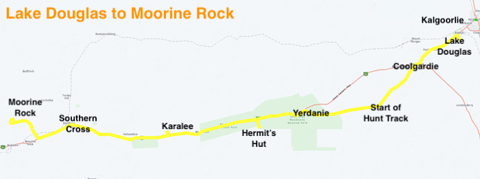
Lake Douglas to Gnarlbine Rock
We pulled into Ampol Coolgardie to refuel and were presented with a dire situation. The coffee machine was out of order. The Road Trip continued regardless.
The Pioneer Cemetery at Coolgardie is always worth a visit. It was used for only two years before the Coolgardie Cemetery was opened. There is often confusion between the two.
We visited a pioneer well at Gnarlbine East, probably of 1890s vintage, and then drove back 200 metres to Hunt’s Well, close to the eastern edge of the rock.
-

- At Hunt’s Well, Gnarlbine.
-

- Hunt’s Well, Gnarlbine
We were now on Hunt Track and we followed it to Gnarlbine West. It was only in October 2021 that this section of Hunt Track was properly delineated and connected with the Track further west.
On that same Trip in 2021 when we found the historic track between Gnarlbine East and Gnarlbine West we also located a pioneer well in extremely thick vegetation to the north-west of the rock. It had been lost for at least 50 years, perhaps quite a bit longer. The flagging tape we had left on our previous visit made it easier to find this time – but still very difficult to get to. Dense thickets and scratchy dead wood made the task all the more difficult.
Hunt Track
On the way to Prince of Wales turnoff someone has indicated the location where a woodline crosses Hunt Track by creating a ‘File Tree’. Scotty Wilson located this woodline in 2019 by clever interpretation of Google Earth mapping. There are still numerous artefacts (discarded tobacco tins, dog spikes and other rubbish) in the vicinity.
-

- Finding artefacts at the File Tree.
-

- File Tree
After lunch at the abandoned Prince of Wales Mine we continued west on Hunt Track towards Yerdanie Rock.
-

- The Goldfields Woodlands National Park boundary is marked by a massive, industrial scale firebreak.
Yerdanie Rock
We stopped at Yerdanie to climb the rock and, later, inspect Hunt’s Well that was rediscovered in 2020 after being ‘lost’ for more than 100 years.
-

- An official Trig Point cairn has been built at the summit of Yerdanie Rock – well after explorer/surveyor C.C. Hunt put through his Track.. Gnarlbine Rock is visible from this point and when marking his Track, Hunt was able to take a bearing to Gnarlbine and confidently follow that course when in thickets and other dense vegetation that obliterated any hope of navigating by direct sight,
-

- Hunt’s Well at Yerdanie was ‘rediscovered’ in 2020.
Hermit’s Hut
The westward push continued to Boorabbin and James led the convoy to the Hermit’s Hut. Sadly but predictably it had been the victim of arson. Once the track from Great Eastern Highway that passed by the Hut was straightened and otherwise improved the structure became visible to anyone passing. It was previously screened from passing traffic (virtually none) and its location was known only to the cognoscenti. A small piece of bush history destroyed. Sad.
-

- A victim of senseless arson.
-

- A ship’s container at the Hermit’s Hut used as a water tank.
Karalee
Most participants in the Trip had visited Karalee numerous times. It was therefore just a quick visit to see the Bicentennial Plaque that we relocated to its correct home at Karalee in 2021.
-

- The relocated plaque and an accompanying plaque explaining the reason for the relocation at Hunt’s Dam at Karalee.
-

- Beautifully restored timbers.
-

- Karalee Reservoir
-

- Karralee Aqueduct supports.
Kodjerning
The day was disappearing fast and we pushed on towards Kodjerning Well, one of Hunt’s Wells that Cockburn 4WD Club and Mitsubishi 4WD Club had refurbished in 2021.
-

- Hunt’s Well at Kodjerning was restored in 2021 by Cockburn 4WD Club and Mitsubishi 4WD Club.
Moorine Rock Camp
We had used this campsite when we refurbished Hunt’s Well at Kodjerning, and his well here. It’s a great spot – plenty of sites, no passing traffic, secluded, and lots of firewood. The wildflowers were a bonus.
-

- Hunt’s Well at Moorine Rock.
-

- Australia gnamma at Moorine Rock.
-

- Micaela and Jeff’s camp.
-

- James and Tim’s camp at Moorine.
The last night of an extended trip has the propensity to be tinged with melancholy. But the campfire ‘competitions’ removed that possibility and Micaela’s Damper Demonstration and Presentation topped off a memorable night.
-

- Damper in preparation. The aluminium can disintegrated.
-

- It was delicious.
Finish of the Road Trip
The Road Trip finished at Moorine Rock and people made their own way home from there.
The Centre of Western Australia Road Trip would not have been possible without input by Scott Overstone and Andrew Brooks in contacting station owners and pre-Trip admin in my absence overseas. In addition, Scott performed the Sweep role during the Road Trip and Andrew was the Communications Coordinator, both vitally important roles for an Extended Road Trip with a large number of participants.
Clearly, the precise centre of Western Australia (+/- 20mm) would not have been able to be accurately determined without the professional input of Steve Leipold, principal of Lone Star Surveys. Steve’s explanations to the group added greatly to the understanding of the process.
Jake Wilson gave our group a personal tour of the small scale mining operation at Tin Dog Mine. Thanks Jake. Hope you find more gold.
The input from Scotty Wilson on the history and geology of the country we covered added greatly to the experience. Scotty readily agreed to delay the marking out of his mining lease so we could all be part of the process. With his son, Jake, he enabled the group to come onto a working mine, visit an open cut pit, and experience small scale mining up close. His knowledge on the broad history of the Goldfields is unsurpassed and his readiness to share that information was much appreciated.
Back to Exploring the Eastern Goldfields
© 2022 Kim Epton
Feel free to use any part of this document but please do the right thing and give attribution. It will enhance the SEO of your website/blog and that of the Cockburn 4WD Club
1004 words.
20 photographs, one image.
Photographs
Micaela Anderson
Kim Epton
James Hay
Entire Report
5803 words
170 photographs
7 images
See Terms of Use