Warramurrup Track and Reef Beach

Warramurrup Track provides access to the eastern end of Reef Beach. This 14 km track starts at Borden-Bremer Bay Road about 20 km west of Bremer Bay township.

The start of the track is quite open and sandy. Midway it becomes rocky, with a noticeable downward slope.

Closer to the beach there is fairly thick vegetation close to the track. Your vehicle will get scratched. Overall, the track descends 180 metres.


The track appears to finish 100 metres from the beach, however, there is a pathway to the white sand.

To the left (four kilometres east) is Foster Beach. The magnificent Reef Beach (WA Beach 323) stretches more than eight kilometres to the west.

A discontinuous reef parallels the beach for much of its length. Waves break on this reef then reform to break again on the beach itself with numerous strong rips. All in all, very unusual beach and surf conditions.

The dunes backing the beach are some of the most active on the southern coast. They extend inland for more than five kilometres.

The beach itself is wide, very convoluted and complex, with heavy sand. The views, wild ocean, expanses of intense white sand, sense of remoteness, constant wind, interesting birdlife, and pristine atmosphere provide a magnificent experience.  The realisation that one is privileged to be able to access such a raw assault on the senses in a beautiful setting is humbling and pleasing. Or you could just go fishing.

The way off the Beach is via Reef Beach Road, a rough track that heads north about a kilometre short of the western end of the sand.

At the bottom of this ‘Exit Dune’, and well protected from the incessant winds, is a fishing camp area and hut.

A few hundred metres before Reef Beach Road intersects with the sealed Borden-Bremer Bay Road there is a convenient spot to air up. The Reef Beach Road is just shy of 10 kilometres in length. It is rough and rocky, however, it presents no difficulty if driven at a sensible speed.

The trip from Borden-Bremer Bay Road down Warramurrup Track, along Reef Beach and then up Reef Beach Road back to Borden-Bremer Bay Road could be done in around two hours but this allows only very little time to appreciate one of the finest and most unusual beaches in Western Australia.


© 2023 Kim Epton
Feel free to use any part of this document but please do the right thing and give attribution. It will enhance the SEO of your website/blog and that of the Cockburn 4WD Club.

556 words.
14 photographs.

Photographs
Warren Peers
Kim Epton

See Terms of Use


Hunt Track – Gnarlbine to Moorine

Lake Douglas to Gnarlbine Rock

We pulled into Ampol Coolgardie to refuel and were presented with a dire situation. The coffee machine was out of order. The Road Trip continued regardless.

The Pioneer Cemetery at Coolgardie is always worth a visit. It was used for only two years before the Coolgardie Cemetery was opened. There is often confusion between the two.

We visited a pioneer well at Gnarlbine East, probably of 1890s vintage, and then drove back 200 metres to Hunt’s Well, close to the eastern edge of the rock.

We were now on Hunt Track and we followed it to Gnarlbine West. It was only in October 2021 that this section of Hunt Track was properly delineated and connected with the Track further west.

On that same Trip in 2021 when we found the historic track between Gnarlbine East and Gnarlbine West we also located a pioneer well in extremely thick vegetation to the north-west of the rock. It had been lost for at least 50 years, perhaps quite a bit longer. The flagging tape we had left on our previous visit made it easier to find this time – but still very difficult to get to. Dense thickets and scratchy dead wood made the task all the more difficult.

Hunt Track

On the way to Prince of Wales turnoff someone has indicated the location where a woodline crosses Hunt Track by creating a ‘File Tree’. Scotty Wilson located this woodline in 2019 by clever interpretation of Google Earth mapping. There are still numerous artefacts (discarded tobacco tins, dog spikes and other rubbish) in the vicinity.

After lunch at the abandoned Prince of Wales Mine we continued west on Hunt Track towards Yerdanie Rock.

Yerdanie Rock

We stopped at Yerdanie to climb the rock and, later, inspect Hunt’s Well that was rediscovered in 2020 after being ‘lost’ for more than 100 years.

Hermit’s Hut

The westward push continued to Boorabbin and James led the convoy to the Hermit’s Hut. Sadly but predictably it had been the victim of arson. Once the track from Great Eastern Highway that passed by the Hut was straightened and otherwise improved the structure became visible to anyone passing. It was previously screened from passing traffic (virtually none) and its location was known only to the cognoscenti. A small piece of bush history destroyed. Sad.

Karalee

Most participants in the Trip had visited Karalee numerous times. It was therefore just a quick visit to see the Bicentennial Plaque that we relocated to its correct home at Karalee in 2021.

Kodjerning

The day was disappearing fast and we pushed on towards Kodjerning Well, one of Hunt’s Wells that Cockburn 4WD Club and Mitsubishi 4WD Club had refurbished in 2021.

Moorine Rock Camp

We had used this campsite when we refurbished Hunt’s Well at Kodjerning, and his well here. It’s a great spot – plenty of sites, no passing traffic, secluded, and lots of firewood. The wildflowers were a bonus.

The last night of an extended trip has the propensity to be tinged with melancholy. But the campfire ‘competitions’ removed that possibility and Micaela’s Damper Demonstration and Presentation topped off a memorable night.

Finish of the Road Trip

The Road Trip finished at Moorine Rock and people made their own way home from there.

The Centre of Western Australia Road Trip would not have been possible without input by Scott Overstone and Andrew Brooks in contacting station owners and pre-Trip admin in my absence overseas. In addition, Scott performed the Sweep role during the Road Trip and Andrew was the Communications Coordinator, both vitally important roles for an Extended Road Trip with a large number of participants.

Clearly, the precise centre of Western Australia (+/- 20mm) would not have been able to be accurately determined without the professional input of Steve Leipold, principal of Lone Star Surveys. Steve’s explanations to the group added greatly to the understanding of the process.

Jake Wilson gave our group a personal tour of the small scale mining operation at Tin Dog Mine. Thanks Jake. Hope you find more gold.

The input from Scotty Wilson on the history and geology of the country we covered added greatly to the experience. Scotty readily agreed to delay the marking out of his mining lease so we could all be part of the process. With his son, Jake, he enabled the group to come onto a working mine, visit an open cut pit, and experience small scale mining up close. His knowledge on the broad history of the Goldfields is unsurpassed and his readiness to share that information was much appreciated.

Back to Exploring the Eastern Goldfields


© 2022 Kim Epton
Feel free to use any part of this document but please do the right thing and give attribution. It will enhance the SEO of your website/blog and that of the Cockburn 4WD Club

1004 words.
20 photographs, one image.

Photographs
Micaela Anderson
Kim Epton
James Hay

Entire Report
5803 words
170 photographs
7 images


See Terms of Use

Exploring the Eastern Goldfields

Centre of Western Australia to Lake Douglas


The expedition made its way out to Glen-Ayle Carnegie Road, after which time Gary took over as Trip Manager. In masterful fashion he proceeded to get the expedition back on schedule. It was important to reach Laverton this night because we had arranged for the managers of the Great Beyond Explorers’ Hall of Fame and Visitor Centre to open the venue tomorrow 30 minutes earlier than normal, specially for us.

Carnegie Station

Carnegie Station was the first milestone in our push to Laverton. Diesel $3.25L. There was a buzz at the station as they were preparing for muster two days hence, and a dozen or more casual hires were expected to arrive in the next 24 hours. Accommodation, catering, two beers, and $200 per day.

Carnegie is on the south-western edge of the Little Sandy Desert, about equidistant between Perth and Alice Springs. It is an important stop for travellers on the Gunbarrel Highway.

After ‘information received’ discussion took place over the track to Prenti Downs – our planned route. After further investigation it was determined that the information about the track was presented (innocently) from a position of ignorance/inexperience. As it is a mapped road (rather than a station track) we elected to stay with our planned route and, as events unfolded, it was an easy drive. If we had taken the alternative route it would have been an extra 325 kilometres – it was never really an option. Just as we were about to depart Shaun noticed that the right rear tyre of his Prado was leaking air. The quickest solution was to swap the wheel.

Prenti Downs

We arrived at Prenti Downs Station just as the daylight was starting to fade. After talking with the station managers and, given the lateness of the hour, we changed our route to arrive at the Great Central Road further east than we had originally intended. Darkness fell as we travelled towards Cosmo Newberry. It was difficult to see the crepuscular wildlife and, sometimes, even the track.

After turning right onto Great Central Road it was not long before we hit the bitumen, arriving at Laverton Caravan Park just after 8.00 p.m. Set up camp, shower, dinner.

A taxing drive, a long day, a successful but tiring event.

Laverton

Today is Loud Shirt Day. It is also a scheduled visit to the Great Beyond Visitor Centre. Coffee, information, education – an hour well spent.

It was time for Scotty to again be Trip Manager – it is his country.

We headed south out of Laverton and around the sunrise Dam Mine, boldly driving along a mine road that locals use for transit through the mine. No one stopped us so it was on with the journey south.

Lake Carey

We crossed the southern end of Lake Carey.

This a heavily mined and prospected area. Evidence of years of mining is everywhere,

Bindah Breakaway

The spectacularly eroded geological feature at Bindah Breakaways is facetiously called Linden Bridge.

It was then onto Tin Dog Mine where we stopped for lunch. Scotty and son Jake gave us an extensive tour of their Tin Dog Mine and showed us their small scale gold getting process.

Tin Dog Mine

We left Tin Dog and drove to a disused open cut pit for more interesting commentary by Scotty imparted further commentary on the geology.

With lots left to see and do we had to leave the mine and continue the Road Trip.

Edjudina

After visiting the Edjudina Cemetery we camped on the lee side of a hill to the west. It was still windy but it would have been considerably worse on the other side of the hill.

Yarri Station and Mine

Rob and Tracey volunteered to be Trip Managers for today.

There is a lot of mining and drilling activity at and around the Yarri Station Homestead. We tried to announce our presence but no one was interested so we drove on through. And later repeated the action as we found our route to Monaghan Well.

Monaghan Well

Tracey called a stop at Monaghan Well after tackling a slow, overgrown track for many kilometres. It was her first time driving such an arduous track and, while a great experience for her, it will pale into insignificance after she drives more of our Road Trips.

The track opened out and after negotiating several road realignments resulting from the construction of the Tropicana Highway we were able to find our way to Kirgella Rockhole for lunch.

Kirgella Rockhole

Old Pinjin

Old Pinjin has been in a ruined state for forty or more years.

The water tank among the ruins is actually a repurposed ship’s container. These are seen throughout the bush.

Time was ticking away and we needed to head towards Kalgoorlie quicker and more directly.

Kanowna

Scotty gave us tour of Kanowna. There’s not much left today but it was a roaring town in its heyday.


Lake Douglas

There was little left of the day as the convoy made its way to Kalgoorlie to refuel, resupply and have showers. People made their way individually to the overnight stop at Lake Douglas, a huge free camp area few kilometres west of Kalgoorlie. Wood was difficult to find but we managed to have a decent fire.

Nobody was interested in driving kilometre after kilometre through mud and the possibility of encountering this on the Holland Track was looking likely so it was not a difficult choice to change the itinerary. Swap Hunt Track for the Holland Track – meaning that trip would finish one day early.

Next Hunt Track and More

Back to To the Centre of Western Australia

© 2022 Kim Epton
Feel free to use any part of this document but please do the right thing and give attribution. It will enhance the SEO of your website/blog and that of the Cockburn 4WD Club.

1409 words.
57 photographs, one image
.

Photographs
Micaela Anderson
Kim Epton
James Hay
Louise Leipold
Maria Wilson
Tayla Skewes


See Terms of Use

To the Centre of Western Australia

Shoemaker Crater to Glen-Ayle Station


With the marking of the Crater’s centre completed and duly recorded we headed north to a track that we hoped would take us to Granite Peak Station. A dry creek bed presented a delay in getting the camper trailer through, however, that was the only obstacle before we stopped for lunch at a spectacular, unnamed breakaway near the western boundary of Granite Peak Station.

Lunchtime Breakaway

The Lunchtime Breakaway is really quite spectacular and deserving of an official name.

Station tracks to Granite Peak Homestead presented another navigation challenge, however, the alternatives we chose were successful and we found our way to near the homestead. As is often the case at station homesteads there are tracks going everywhere and finding the right one is difficult. Granite Peak is no different, however, as ‘all roads lead to Rome’, we duly arrived at the homestead and met the owner, Jim Quadrio. After a quick chat and thanks for access to the station we moved on towards Glen-Ayle Station. We were a long way behind schedule.

On our arrival at Glen-Ayle there was no-one home. Doors open, lots of vehicles, dogs, horses, poultry but no humans.

Donna made friends with a filly. Still no humans.

Steve needed to set up a ‘base station’ so he could achieve an accuracy at the Centre of WA of 20-25mm rather than 1-2 metres that could be achieved by using GPS satellites alone. To do this he would need to place a radio at a known, surveyed point that would transmit continuously to him at the Centre of WA. The only known, surveyed point within cooee of our objective was Standard Survey Mark HP 24, 22 kilometres south-east along the Glen-Ayle Carnegie Road from where we currently were at the unoccupied Glen-Ayle Homestead. Graham jumped in with Steve and accompanied by James and Tim they headed off to find the survey mark and set up the base station.

The rest of the crew found a good campsite a few kilometres from the homestead. Scott and Kim went back to the station about 6.00 p.m. Still no one home.

The wind continued to howl. It normally calms down after the sun dips below the horizon, however, that didn’t happen. After Steve arrived at the camp he voiced his concerns that the strong winds might blow over the base station during the night.

It was a lazy wind, a very lazy wind.

Some time after darkness fell an animal was heard whining/crying off in the distance. Scotty investigated and brought a dog back to camp. It was obviously a station dog. Why was it out here? It was in a bad way. Scotty and others fed it and set up a comfortable bed for it near the fire and out of the wind.

Glen-Ayle Station to the Geographic Centre of Western Australia

In the morning we returned to the station. There was still no human activity. We reunited the hapless dog with its mates. It perked up immediately.

The yapping dogs caused Colin to appear.

The Story of Little Dog

After brief introductions we advised him that we had found his station dog and that it was ok.  Clearly relieved, he told us the story of Little Dog. It had been missing for four days and the entire Station workforce had been out on motorbikes searching for it. However, the backstory was even more interesting.

In 2008 an adventurous woman was travelling south on the Canning Stock Route with camels. She called in to an aboriginal community and came across a dog that she believed was being mistreated so she offered to take it with her – which offer was accepted. When she arrived at Glen-Ayle with her camels and the dog she made the decision to leave the dog at the Station. It was named Little Dog and, coupled with this current event, it is clearly a canine with two fortunate life stories.

Track In

Scotty led the way to the Centre of WA, following wheel tracks of some adventurous visitors who had made their way to the supposed Centre of WA only a few weeks previously. So sad that they didn’t see the real Centre of WA. In a number of places we travelled cross country, along creek lines and through mudholes. Considering that we were in the Little Sandy Desert, there was a fair bit of water laying around. The drive took about an hour.

All vehicles were parked on a clearing at the side of the hill where the supposed Centre of WA is located. A walk track led to the top of the hill on which a small rock cairn had been constructed. Very convenient, very scenic and very much done for the punters. And very wrong.

Steve led the way to the real Centre of WA – more than 200 metres away from the BS location.

Marking the Centre of Western Australia

It was now that the preparation and extra effort last evening by Steve, Graham, James and Tim paid dividend. The base station they installed was sending a continuous signal that enabled Steve’s determination of the Centre to be accurate to within 20-25mm. To achieve this accuracy Steve set the base station over a known point – in this case the closest established Landgate Standard Survey Mark (SSM24). The Base Station receives satellite signals (American GPS and Russian Glonass) and applies a correction, so that the received position matches the SSM position. This correction is then transmitted via a UHF radio repeater to the Rover Unit at the Centre of WA area in real time (Real Time Kinetic). The Rover Unit applies this correction to its received satellite signals. This results in an expected accuracy of ± 25mm in X & Y and ± 30mm in Z.

A Survey Controller (keypad/display screen) communicates with the Rover Unit via Bluetooth to record and set out coordinates.


Geoscience Australia determined the Centre of Western Australia, using a conic projection and updated to GDA2020, to be at:

25° 19′ 41″ South, 122° 17′ 54″ East

-25.32806, 122.29833

51J 429383 17198541

The survey mark our group, led by Steve Leipold,  cemented into position is within 25mm of this.

For a simple explanation of Grid References, Coordinates, Projections, Datums, Tectonic Plates and GPS go here.

It is interesting to note that the Centre of Western Australia using the Linear Method is about 91 kilometre north, in the vicinity of 24° 30′ South, 122° 16′ East.

LOTS of photographs were taken and then it was time to move on.

Photographs of people at the Centre of Western Australia are here.

Next Exploring the Eastern Goldfields

Back to Shoemaker Crater


© 2022 Kim Epton
Feel free to use any part of this document but please do the right thing and give attribution. It will enhance the SEO of your website/blog and that of the Cockburn 4WD Club.

1306 words.
26 photographs, two images.

Photographs
Micaela Anderson
Kim Epton
James Hay
Tayla Skewes
Louise Leipold
Maria Wilson


See Terms of Use

To Shoemaker Crater

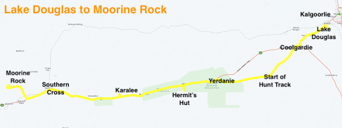
There are easier places to reach than the exact geographical Centre of Western Australia, however, the desire to be the first to accurately determine this unique and iconic location made it an attractive and compelling destination.

To be clear, we were not the first to travel to this vicinity, however, we were the first to determine the exact position, on the ground.

However, our first project was to visit Shoemaker Crater, 105 kilometres north-east of Wiluna, travelling via Wubin, Paynes Find, Youanmi, Sandstone and Montague. At Shoemaker we would determine the centre of the crater and mark it before heading onto the geographical Centre of Western Australia.

Muchea to Wubin

Our Road Trip started on Friday 19 August 2022 at Muchea.

Even though we had not travelled far north of the departure point, a stop at the lookout over New Norcia with its Benedictine Abbey in the distance was too good a photo opportunity to miss.

The farmland land was green and lush after the plentiful winter rains. Sweeping paddocks of bright yellow canola were opposed by fields of green wheat, framed by rows of trees.

Further north we took the Miling North Road past Tim’s childhood farm and were then treated to a detailed description of the countryside and farm operations back in the 60s/70s.

Just short of Wubin, Des and Kay made an ominous radio call that they had to pull over. Scott stayed with them and the convoy continued to the Wubin Wheatbin Museum – an attraction that we had been trying to visit for nearly two years. Covid!

News came through from Scott that the situation did not look good. The gear lever in the Ford Ranger went from Park to Drive and back again with no effect of the vehicle. A known Ford Ranger gearbox problem, even acknowledged by Ford.

Scott continued to Wubin and, with Andrew, arranged recovery of the hapless vehicle and a very disappointed Kay and Des. They stayed the night at Dalwallinu and their vehicle was recovered to Perth.

After refuelling, our convoy continued to the overnight stop at Wubin Rocks, seven kilometres east of the town. We found a good campsite with a reasonable availability of firewood. For such a large area there are precious few campsites with enough area for groups. It was a cold night with a heavy dew.

Wubin to Montague

The first morning of a 10 day Road Trips is all about getting into gear, working out procedures, and being ready to leave by 8.00 a.m.

It was a 152 kilometre run up the Great Northern Highway to Paynes Find, an early gold mining area that is still producing.

Past Paynes Find the cemetery at the abandoned, historic townsite of Youanmi is worth a visit. The number of burial sites related to mining accidents gives pause for thought:

“BANTOW Thomas Henry, 53yrs, d 24 Feb 1920, at the Youanmi GM, Youanmi, Occ: Miner, Cause: While cleaning under the cracker conveyor belt, he was caught by a bucket and dragged under the pulley, Born: Sebastopol Victoria in 1867, …”

The Heritage Loop at Sandstone is a quality tourist attraction. Compact, interesting, different. An Aldi advert? First up was a clever, innovative, goldfields brewery that is the epitome of the ’necessity is the mother of invention’ adage. Basic physics was used to cool the beverages.

Only a short distance further along the Loop is an Outback Icon – London Bridge. A geological oddity and popular picnic spot for locals and tourists alike for well over a century.

Next up is the State Battery – a well preserved piece of our State’s heritage and one that has an important tale to tell of the pioneering gold getting era.

The Heritage Loop turns back towards Sandstone via the Menzies Road past Contradiction Well, a vitally important construction that provided water for survival in a desert environment.

Fuel is available at Sandstone. Card operated, 24/7/365. But not intuitive.

The expedition was now in pastoral country. Along the shoulder of the red dirt road wildflowers softened the harshness of the land.

The seemingly endless winter rain that was the signature of 2022 in Perth is finally a thing of the past as the convoy moved into station country.

We camped a few kilometres north-west of Montague Well and Mine.

Montague to Wiluna

On our way north we stopped at an old Government Well. There is water in the well still, confirmed by the small stone dropped by Micaela. I wonder by how much the depth of wells such as this have been raised over the years by the thousands of stones thrown in by tourists.

The skinny-gutted track eventually took us past the Joyner Find Mine and then onto the Goldfields Highway. It was then only 12 kilometres into Wiluna, a service town for travellers attempting the Canning Stock Route or the Gunbarrel Highway, and surrounding mines and pastoral stations.

Fortunate happenstance meant that we witnessed a camel train come through town.


Wiluna to Gold Mining Lease

We were to meet with Scott Wilson, well known Kalgoorlie gold prospector and Eastern Goldfields Historical Society immediate past president. With Scotty will be licensed surveyor Steve Leipold, Principal of Lone Star Surveys, a mining survey company based in Kalgoorlie. Apart from enjoying a few days out in the bush with our group, Steve will be the authority for determining the location of the coordinates provided by Geoscience Australia for the geographical centre of Western Australia.

Despite prior planning and preparation by Scott Overstone many weeks before our arrival at Jundee Mine (on what was once Jundee Pastoral Station 50 kilometres north-east of Wiluna) it seems that the operators of the mine are totally unaware of who we are and what our intentions are (simple transit through the station). Coupled with our unfortunate timing of arriving at lunchtime we experienced a considerable delay. Once ‘someone’ was aware of our presence we proceeded to the Admin Centre where once again we were totally ignored. Transiting visitors is way down on the list of priorities when there is gold to be dug up. After establishing face to face contact with humans it seems that they were concerned our vehicle(s) could catch fire while traversing tracks on their station and they would then be responsible for our retrieval. Aah, from such fanciful imaginings worksafe empires are built!


While we were waiting at the mine one of the geos brought a few samples of gold.

Once through the mine we met with Scotty and Steve at the Jundee Station Homestead. The delay at the mine allowed Scotty and Steve to check out the tracks I had planned to traverse between the Station Homestead and Scotty’s lease 30 kilometres to the north and in this respect the delay at the mine was perversely fortunate. While passable, the intended tracks were difficult and potentially damaging to vehicles. Scotty had devised a new, much easier route for us.

We arrived at Scotty’s temporary camp at the area known as Coralie Jean, where he was going to mark out a Mining Lease. It was time to meet Maria, Louise and Donna.

Not many people ever get to mark out a Mining Lease – way less than would ever mark out an Exploration Lease which, in turn, would be way less than those who casually pick up a metal detector for a two week sojourn in the goldfields seeking their fortune. It is such experiences that we try to incorporate into our Trips. Banal for some but a unique happening for virtually everyone involved.

Under a magnificent Gidgee tree Scotty took the group through the procedure of how to stake a claim of land for mining.

There is more to prospecting than buying a metal detector and searching anywhere on the red earth of outback Australia for the glint of gold – or a rusty nail. The search for gold and other precious metals is highly regulated.

Scotty had determined that his Exploration Lease was worthy of conversion to a Mining Lease and in casual conversation some weeks before the Road Trip we decided that the marking of the Lease would be a unique activity in which the group could participate.

Such an important undertaking needs the attendance of a surveyor. Scotty has engaged Steve Liepold of Lone Star Surveys to confirm his Mining Lease boundaries (apart from the commercial arrangements with Scotty, Steve, Louise and Donna were a part of the Road Trip) and we were fortunate enough to be part of that process.

We joined the process to formalise the pegging of Scotty’s latest claim, splitting into two groups, spades and GPS in hand. Pegs were hammered in, trenches dug and a new Mining Lease was created!

Gold Mining Lease to Shoemaker Crater

Task completed, we headed north along a creek bed to the Christopher Dean track. We intended to stop as soon as we found an acceptable campsite. A couple of ks along the track Scotty pointed out some interesting rock formations to the north. We deviated off the track to investigate.

The track towards Shoemaker Crater was unknowingly missed and after a kilometre or so of travel in the wrong direction we stopped and camped for the night. There would be plenty of time in the morning to pick up the correct route.

Today we would reach the Centre of Shoemaker Crater.

The Shoemake Crater, with an outer rim diameter of 30 kilometres, is one of the largest impact craters in Western Australia. It is a large bowl-shaped flat structure, arid and contains a few salt lakes. The inner rim is more easily discerned as a crater.

After a bit of challenging navigation and some cross country travel we arrived at what we believed to be the centre of the crater.

Surveyor Steve got to work and showed that our ‘carpark’ was only about 50 metres from the exact centre of the Crater. This data was derived from a geolocation package, after Hawke 2003.

With a few minutes work Steve determined the location of the centre of the crater. This significant point was duly marked with that quintessential Australian indicator – a star picket.

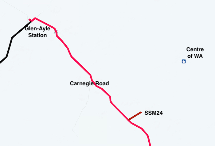
It was time to move on to Granite Peak Station, Glen-Ayle Station and then the Centre of Western Australia.

Next  – To the Geographical Centre of Western Australia


© 2022 Kim Epton
Feel free to use any part of this document but please do the right thing and give attribution. It will enhance the SEO of your website/blog and that of the Cockburn 4WD Club.

2090 words.
47 photographs, three images.

Photographs
Micaela Anderson
Kim Epton
James Hay
Tayla Skewes
Louise Leipold
Maria Wilson

Helmi Holzheuer provided helpful notes for this part of this Trip Report.


See Terms of Use

South Coast Beaches

Australia Day 2022 was on a Wednesday. This allowed for an extended break to explore some previously untravelled beaches on the south coast between Cape Riche and Bremer Bay. The Wellstead Bush Camp was an excellent place from which to branch out to the beaches on each of the four days we had available to explore.


Saturday
Cape Riche to Swan Gully

First stop was the tiny hamlet of Wellstead, only 500 metres from the Bush Camp.

Sandalwood Road took us out of Wellstead to the Cape Riche Campground. The inspection circuit of the campground (good but not suitable for groups) was completed and we headed to the debouch of the Eyre River at Cheyne Inlet Beach.

Leaving the Cheyne Inlet Beach we drove north to the headland overlooking it. Some gnarly tracks made the drive more interesting.

A track that parallels the coast eventually leads to Schooner Beach. After travelling to the north of the beach we exited near the northern end with the intention of returning to where we had first accessed the beach. This entailed a circuit back to a large gravel area from where we had started, however, the track close to end of this ‘circuit’ was badly washed away and I chose not to drive it – believing that a rolled vehicle or panel damage could result.


We returned to the northern end of the beach, drove south 600 metres and exited the way we had first entered, allowing us back onto Sandalwood Road and then to a track that varied from 100-500 metres inland that would take us north-north-east along the coast to Swan Gully. A number of short tracks branched off to the east allowing views of spectacular cliffs, with just one leading to a beach.

This ‘inland’ coastal track continued to Swan Gully. We worked our way downslope to the beach and made a 500 metre run along the sand. The beach sand was very soft.

The track from Swan Gully took us back to farmland from where we followed fencelines out to Pallinup Road and eventually South Coast Highway to conclude a great day of sightseeing and four wheel driving.

Before we returned to the Wellstead Bush Camp we stopped at the tiny hamlet of Wellstead – postcode 6328, 100 kilometres east of Albany.

Sunday
Swan Gully to Boat Harbour to WA Beach 334

Nine vehicles headed out to the now familiar Boat Harbour Road, off the South Coast Highway, and along the fencelines to pick up the Long Beach Track to the coast.

At a T junction close to the coast what looked like an interesting track lead off to the south-west. We checked it out and then returned to the junction. Five hundred metres to the north-east beach access is via a steep track that, because of a 90° turn partway up, looked like it could present some challenges on exit.

We drove the full length of the beach and returned to the exit point. I rearranged the order of the vehicles in anticipation of difficulties in ascending the hill, however, it was reasonably easy and everyone got to the top of the cliff in time to see a pod of about 20 dolphins frolicking in the water on the surf line.

Time to move on.

It was an interesting drive to Boat Harbour with some good views. On approach to the beach the track doubles back on itself to the access point at the southern end of the beach.

Time for a swim. The southern end of the beach is protected and very calm for a Southern Ocean beach.

We then did the obligatory drive of the full length of the beach.

Leaving Boat Harbour, we took a track roughly east for 4.5 km to gain access to an unnamed beach (WA Beach 334). Once again the entry track was steep, sandy and looked like getting back up would be an issue. However, the track out (right next to the inward track) was firm and presented little challenge – at the start.

Know that each of the drivers of the vehicles shown in the following pics is very experienced driving on beaches The tyre pressure of each of the vehicles was around 10 psi. It was a very soft beach. Keyboard warriors be still!

Further up the beach Greg and Sam were having their own difficulties in the Discovery 4. Rod had driven up to the end of the beach in his lighter Hilux and only just managed to turn around without getting bogged. Not so Greg when he tried.

The exit track followed a creek line for just under a kilometre and then dropped down into the creek itself. It was then narrow, twisty and very, very scratchy. Not a pleasant drive for the next couple of kilometres. The track opened out but only for a short distance. It was back to a similar tight, scratchy experience that had everyone commenting. Definitely in my Top 10 of unpleasant tracks.

The scratching finished and very soon we were on Pallinup Road and, not longer after, at the Highway.

We were treated to a feed of koonacs, courtesy of host, Rob. He took time out to drag a couple of his dams and shared the spoils with everyone. What a great gesture.

Who Went

As is often the case with Trips of this duration and distance people are involved for varying amounts of time. Eight vehicles and seventeen people made it out onto the tracks.

Monday
Groper Bluff to Millers Point

Once more we used Boat Harbour Road to get to our coastal playground. We headed for the impressive Groper Bluff.

As the track approaches Mount Groper it narrows and deteriorates. About a hundred metres before our turnaround point, at the top of the ‘spine’ of the Bluff, the track turns radically to the right. Straight ahead is over the spine.

To the north are three unnamed beaches – WA Beaches 329, 330 and 331. To the south and trending west is Groper Bluff Beach.

We turned around and retraced our path for two kilometres, negotiating a couple of tricky jump ups before turning onto a north-south track that would take us to Pallinup Beach.

The jump ups on the Groper Bluff track were just a warm up. The track to the beach looked innocuous enough – all downhill.

Pallinup Beach is a popular fishing spot.

We travelled the length of the beach and then ducked into the lee of some dunes on the shore of Beaufort Inlet to have lunch. Alan had reported that the start of the next beach (WA Beach 325 – otherwise unnamed) was very soft and essentially impassable. I found a track from our lunch spot to Pallinup Estuary Road and we headed out the bitumen.

A couple of kilometres along the road we turned in towards Millers Point, a popular campground with a full time camp minder.

Tuesday
Reef Beach to Bremer Bay

We turned off the Bremer Bay Road into Reef Beach Track and aired down. There are no difficulties on the track and it is quite open compared to a few years back when vegetation was close in.


Close to the beach (next to a fishermen’s camp and hut) there are two choices – up and over a steep dune or a track to the left that eventually arrives at the beach about 400 metres on. Adi showed the way over the dune and the convoy followed one by one.

We drove Reef Beach to its eastern extremity and then returned to the access/egress point – Warramurrup Track. The first couple of hundred metres of the ascent away from the beach presents some mild challenges. Rod found a hole that wasn’t meant to be there.

Thick bush on either side of the track means its width was little more than that of a single vehicle. There are no passing area or pull off places. Part way up the slope we encountered another 4WD Group in an extremely tight section of track. I got out and spoke to driver of the first vehicle.

“I’ve got six vehicles with me.”

He replied, “I’ve got eight.”

“You win!”

“Are you with a Club?”, he asked

“Yep – Cockburn 4WD Club. You?”

“Yep.”

“Ok, I’ll get my group to pull off the track into the bush. Give me a few minutes.”

Eventually the way was clear for the oncoming group to pass through. We continued on.

As we got out into more open country it was clear that the beginnings of corrugations were starting to appear on the track. In a few places even the beginnings of a few moguls were apparent. Not yet formed but the genesis was obvious. Clearly the group we had just passed did not have low enough tyre pressures. Inexcusable for such an experienced, high profile group.

Towards the end of the track is a low lying area that often prevents access to the beach.

Warramurrup Track leads to the bitumen road into Bremer Bay. We cruised into town and headed to the beach, past the caravan park where holiday makers were packed in side by side. But getting away from it all!

The bar of the Bremer River mouth was open, preventing access to the beach and the tracks to north and east. The intention was to visit the Wellstead Museum later in the day so it was no issue to reschedule this as our lunch stop.

Wellstead Museum is well worth a visit. A good proportion of the exhibits would be contemporary items for many of the visitors when they were growing up although they are ancient history to the younger people walking through the various sheds.

We made our way back to the Wellstead Bush Camp, comfortable that a few more kilometres of our project to drive Western Australia’s beaches had been ticked off.

Wednesday
Wellstead to Cockburn via Stirling Drive

The way back to Cockburn was via the wonderful Stirling Drive, one of our State’s great drives, and Great Southern Highway.

Multiple, simultaneous mechanical issues just north of the Ranges ate into the day but with so many talented mechanics at hand it was only a matter of time before the convoy was rolling again.

Dan’s fuel computer told him he wouldn’t make Katanning but it was wrong. After refuelling we went our separate ways from this thriving Great Southern town.


© Cockburn 4WD Club  and Kim Epton 2022
Feel free to use any part of this document but please do the right thing and give attribution. It will enhance the SEO of your website/blog and that of the Cockburn 4WD Club.
2125 words, 78 photographs, one image.

Photographs
Kim Epton
Dee Wales
Dan Wales
Alan Gibbs
Janine Milne
Graham Salter


See Terms of Use

Hunt for Hunt’s Wells 2021

The Plan

A mid week Trip to confirm the location of Koorkoordine Well, find Hunt’s Well Boorabbin Well, find a secondary well/soak at Boorabbin, visit Yerdanie Well, confirm a section of the Hunt Track from the east of Gnarlbine Rock to the west, and find a lost soak on the west side of Gnarlbine.

We achieved everything we set out to do, plus more, making it a very successful Trip.

Heading East

Scott Overstone, Kerry Davies and I headed east on Sunday morning, stopping just east of Burracoppin at the site where the No. 1 Rabbit Proof Fence crossed in days past.

We turned off the Highway at Noongar, to head to Moorine Rock.  In June 2021 we refurbished Hunt’s Wells at Moorine Rock and Kodjerning and this was a good opportunity to check on them.

Local roads took us to Lake Kookoordine, seven kilometres north of Southern Cross. We wanted to confirm that the location of Hunt’s Well at Kookoordine was correctly identified. Hunt described the well as being “(8) chains from the base of a granite rock, eastern side”. Our investigations confirmed this to be reasonably accurate. A more detailed description of a rock two chains to the north-west of the well was also confirmed as accurate.

We left Southern Cross and refuelled at Yellowdine before turning in to the pumping station at Karalee. A newly-made track allowed access to Hunts Track adjacent to Morlining Rock. Two kilometres east we located a very overgrown track that took us south towards the south-west extension of Karalee Rock where I had pinpointed a pioneer well from reference to satellite images. The drive in was tough and once adjacent to the predicted position of the well we got out and walked.

At Karalee we checked on the two signs that we positioned/repositioned in early August 2021 and then continued on towards Koorarawalyee.


We spent some time between the Vermin Proof Fence and the Gilgai Pumping Station searching for evidence of the wooden pipeline that was in use around the time of the Great Depression. Concrete plinths, wooden staves and loops of thick retaining wire are in abundance. Daylight was slipping away and it was time to head to the planned overnight stop at Boorabbin.

At Boorabbin

Early in the morning we searched for an overgrown well/soak in an area identified for us by researcher Eric Hancock.

We then walked to the top of Boorabbin Rock.

It was time to find Hunt’s Well, again in a defined area. We gridded the search area and spent a few hours thoroughly dissecting it.

The Hunt Track follows the current day pipeline from Koorarawalyee to within about four kilometres of Boorabbin Rock, at which point the pipeline deviates due east. The Track enters Boorabbin Rock at the northern end. We decided to follow it to the west.

Our tasks at Boorabbin were completed ahead of time so we packed and headed to the highway.

Hunt Track

After checking out Hunt’s Well at Yerdanie Rock we continued east along the Hunt Track. A directional sign at the Rock was missing, as were a few others along the way. Not many vehicles have been using the Track between Yerdanie and Gnarlbine.

Gnarlbine Rock

As we approached Gnarlbine Rock West the way was blocked by two fallen trees which in any case was of no import because the Track finished just beyond them. We turned around and drove to Gnarlbine Rock East where we followed the Track west around the base of the rock and found a pleasant campsite.

Next morning we set about finding the Hunt Track between Gnarline East and Gnarline West. The path from Point A to Point B depicted on the map below was not immediately clear but after plenty of effort and driving backwards and forwards from the known Track to where we thought the Track was routed we eventually were able to connect the two parts of the Track and an additional 1.4 kilometres was added to the known, usuable Hunt Track. After repositioning the directional sign a kilometre west of the rock we retired to camp for lunch.

After lunch we determined to find Hunt Track to the east of Gnarlbine. We found a way through a disused quarry to where an overgrown track was faintly visible. We followed this east for 1.3 kilometres (looking good) and then north for a further 1.5 kilometres before deciding that it was not going to take us in the direction we required. We retreated to a Y junction noticed on the outward journey and headed south-east. After two kilometres this, too, was abandoned.

It was time to head back to camp.

Scott Wilson arrived from Kalgoorlie after dark and lively conversation ensued around the campfire.

Next morning we headed to Gnarlbine West to locate the historical track Scott had described the previous night. That was relatively easy and there are now two ways ‘onto the rock’ (or ‘off the rock’ depending on direction of travel).

Pioneer Well at Gnarlbine West

I had plotted the location of a pioneer or native well at the western edge of Gnarlbine West from a map shared with me by researcher Eric Hancock. It was in very solid thickets in the usual band of vegetation that surrounds granite outcrops. Granite outcrops have their own ecosystem and act as island sanctuaries for a whole range of wildlife. In the south-west of Australia they are characterised by a belt of thick vegetation around the base of the rock. In many cases, due to the large amount of runoff from the rock, this vegetation is swamp-like, even though they are located in semi-arid country.

In an open area away from the rock we noticed a gully leading off the rock. Scott followed this up. Not easy. The thickets are almost impenetrable. After some time but only 20 metres he shouted that he had found a well. Time for Scott W, Kerry and me to crash through the thickets. Tough work. The thickets rip clothes and skin.

The well is quite large and of dry stone construction. The dense thickets and the ‘matting’ effect of the vegetation make it difficult to see and properly discern its shape and size. It has been hidden for some time – at least 50 years quite likely up to double that time.

Banks Rock

We left Gnarlbine mid morning heading south on Victoria Rock Road, intending to check out Banks Rock before finishing at McDermid Rock. The track into Banks Rock is difficult to find and is actually off a woodline that sort of parallels Victoria Rock Road.  The 3.5 kilometre access track is full of twists and turns.

Lake Johnston

Leaving Banks Rock we detoured a few kilometres along the Hyden-Norseman Road to have lunch at Lake Johnston.

The directional/informational sign at the intersection of Hyden-Norseman Road and Victoria Rock Road is incorrect albeit ultimately helpful. The distance to the next available fuel is correct. However, it is at Hyden, not Kondinin.

McDermid Rock

McDermid Rock is an interesting inselberg 2.6 kilometres south-west of the intersection of Victoria Rock Road and Hyden-Norseman Road. Although we had climbed it many times in the past we considered the view from the top to be worth the effort. Unlike better known Hyden Rock (Wave Rock), this granite outcrop has three ‘waves’.

We were way ahead of our schedule so we decided to camp at Emu Rock on the Holland Track, 140 kilometres further west of our original planned overnight stop.

On the way to Emu Rock we visited The Breakaways. Intrepid campers have extended the camping area 1.5 kilometres south of the ‘official’ area. It’s a huge camp area.

Emu Rock

We were still ahead of time and pushed on to Emu Rock to camp the night. There was plenty of regrowth in the area after the devastating fires a couple of years previously. Emu Rock is a good, flat campsite overlooking the lake with enough room for 20 or more vehicles. It is on Holland Track south of the Hyden Norseman Road and 1.7 kilometres south-west of the State Barrier Fence.


The drive out to the big, wide, open Hyden-Norseman Road was easy and then it was an uneventful trip back to Cockburn.


© Cockburn 4WD Club and Kim Epton 2021
Text and layout – Kim Epton
1809 words
Photographs – Kim Epton, Scott Overstone, Scott Wilson
46 photographs, four images.

Feel free to use any part of this Trip Report but please do the right thing and give attribution.
See Terms of Use

Rescuing Explorers’ Wells in the Yilgarn

Cockburn 4WD Club is aligned with the Wells and Tracks Project and actively pursues the objectives of finding, refurbishing and protecting explorer and pioneer wells.

In June 2021, in conjunction with three Members of the Mitsubishi 4WD Owners Club of WA, we travelled to the Yilgarn to rescue Kodjerning Well, one of the 26 wells built by explorer/surveyor C.C. Hunt in 1865/66 to secure a track from York to the Hampton Plains. It had been degraded since 2015, and possibly before, and was in danger of imminent collapse.

We set up camp at Moorine Rock and on Thursday afternoon refurbished the well there.

On Friday our convoy of nine vehicles travelled to Karolin Rock and removed the incorrectly placed Bicentennial plaque from there. It will be relocated to Karalee Rocks in the near future.

As part of Australia’s Bicentennial celebrations in 1988, plaques were placed at each of Hunt’s Wells as part of the York to Goldfields Heritage Trail. For unknown reasons but probably because of the similar sounding names, the plaque destined for Caroling Rocks was placed at Karolin Rock, 90 kilometres away. Bush historian and keen follower of Hunt’s exploits, Gary Arcus, noticed the out-of-place plaque when he visited Karolin Rocks in mid 2020, not long after Covid19 travel restrictions within Western Australia were lifted.

Apart from the fact that Karolin Rock was not on the Hunt Track, it is clear that the wording on the plaque referred to Carolling Rocks not Karolin Rock.

Both Karolin Rocks and Caroling Rocks are in the Shire of Yilgarn, which made coordination of the relocation of the plaque hassle free. However, the plaque will not be relocated to Carolling Rocks. The rock Hunt referred to as Caroling/Karolling in 1865-66 is actually current day Karalee Rock. However, the name Karalee wasn’t used until 1890 when recorded by surveyor N.M. Brazier. Present day Carolling Rocks are 3.4 kilometres south-south-west of Karalee. It is likely that Hunt never visited these rocks.

I had made made arrangements with Robert Bosenberg, Executive Manager Infrastructure at the Shire of Yilgarn for our IBC to be filled with 1000 litres of water at Moorine Rock (the tiny town on Great Eastern Highway). We had to meet with the Shire team there at 1100. The IBC was filled and we headed to Kodjerning Well, 13 kilometres to the north.

The fence had dropped, the gate wouldn’t open, the well was overgrown with vegetation, trees had fallen on the fence and other vegetation was crowding the area. More importantly three large holes had formed behind the wall of the well and it was unstable and unlikely to withstand many more exceptional rainfall events.

On Saturday we spent all day at Kodjerning to complete the task. Joanne and Tracey worked as hard as the men with Tracey assisting in creating a new oxymoron for the lexicon – “light mattock work”.

After two days of hard work we decided a Road Trip was in order. On Sunday morning we travelled to nearby Keokanie Rock where C.C. Hunt established a depot in 1865 while trying to find a way through to Lake Koorkoordine, north of Southern Cross.

Next stop was Sandford Rocks, a huge granite outcrop along Hunts Track.

We left Sandford Rocks to see the most recently-worked open pit at the Edna May mine at Westonia – just as they were about to blast.

It was then onto Boodallin Soak on the Westonia Commons.

We drove through the Reserve, removed a few trees from across the track, and headed to Burracoppin. Hunt’s Well at Burracoppin is at Lansdowne Hill, where a motocross track has been constructed. A sign with “Hunts Well 1865” painted on it is located at the carpark. Hunt’s Well is not there. Nor, now, is the sign.

Eight hundred metres east of the well is an Information Point about the 1800+ kilometre long Rabbit Proof Fence, surveyed and built 1901-1905. This was early but failed attempt at biosecurity – the rabbits reached the fence before it was finished. The gates and wells along the Fence are numbered from Burracoppin.

We continued along Goldfields Road to Carrabin. A great drive. Andrew’s need to refuel there created a serendipitous moment for the car lovers in the group as we were able to look in a car transporter with a difference – full of exotic and expensive automotive machinery.

On Monday we headed back to Karolin Rock to start clearing access to the well before returning home.

Scott had an appointment at Mukinbudin for a few hours hence so he stayed at Karolin, continuing to clear away overgrown vegetation. In the process he found a third well.

Clearly the three structures are linked, however, until the overgrowth is removed, how the system operated is unclear.

[2022 Update after overgrowth was removed]

Thanks to Anne Brandis of Mukinbudin for coordination assistance in the planning stages of this Trip/Project.

Thanks to Club Member Steve Cook for valuable advice on how to refurbish Kodjerning Well.


© 2021 Cockburn 4WD Club and Kim Epton
1177 words and 37 photographs.

Feel free to use any part of this document but please do the right thing and give attribution. It will enhance the SEO of your website/blog and that of the Cockburn 4WD Club.
See Terms of Use

Esperance-Balladonia-PeakCharles-Lake Sharpe/Lake Hope-Corrigin

A seven day, 1750 kilometre Road Trip out to Balladonia, returning along the Old Coach Road/Telegraph Track to Dundas then Peak Charles before exploring the remote Lake Sharpe Track and Lake Hope Track.

We took Goldfields Road and then Fisheries Road out of Esperance to Condingup.

Condingup

A tour of the township revealed that Condingup is more than just the tavern and general store. With a population of more than 400 it is quite a bit bigger than one would expect when driving past.

Mount Ragged

Forty seven kilometres along the Track we turned east onto the access track into Mount Ragged. Scott, Howezit, Andrew, Joanne, Peter and Lone elected to make the climb up the Mount. It started raining as they were preparing and continued throughout their walk.

Greg erected his popup gazebo and those who chose not to climb had lunch under the shelter.

We left Mount Ragged and headed north. The track was easy enough.

Further on we searched for and found Juranda Rockhole.

Sixteen kilometres further on we turned into Balbinya.

Balbinya

Balbinya was settled in 1884 by John Paul Brooks, his mother Emily Henrietta and sister Sarah Teresa. They had walked from Albany to Israelite Bay in 1874. Brooks was the first linesman at Israelite Bay Telegraph Station from 1877 to 1883. He managed Balbinya till his death in 1930.

We left Balbinya and continued north. The Track changes markedly from where it intersects with Parmango Road.

The cleared thoroughfare was about 100 metres wide north of from where the Balladonia Track and Parmango Road intersect. The reason for such a wide clearing of vegetation is unknown although it is likely to be the ploughed-in Telstra cable parallel to the track and 50 metres to the east of it.

We turned off the track and drove into Booanya Rock. It was late in the day with rain threatening when we arrived so we continued past the Rock, searching for a suitable campsite, which we found 600 metres along the track.

Booanya Rock

Next morning it was a short drive back on our track to Booanya Rock.

The building at Booanya Rock is being restored.

We headed north and stopped at a dam (empty) where there was plenty of evidence of human activity. One corner of the cement-lined tank and water trough was in good condition.

The next sign of habitation  was Nanambinia, however, the ‘No Trespassing’ signs did not encourage stopping to look around or even take photographs so we continued north towards Balladonia to refuel.

Large Land Snail

As scientists are finding out more about these molluscs, they are more clearly identifying them and allocating them to more precise geographic regions, with resultant name changes. This looks like the Bothriembryon toolinna, however, the location where it was seen is quite a few kilometres from Toolinna Cove. Perhaps it should be known Bothriembryon balladonia. There were thousands of them on the Balladonia Track.

Balladonia

Balladonia was really just a ‘refuelling diversion’ – off our Route and not scheduled for any other activity.

The ‘Road Closed’ sign confronting southbound travellers at the junction of Eyre Highway and the Balladonia Track is an example of bureaucratic laziness. Anecdotally, it is said to have been there for a long time – possibly years. It is totally inaccurate and could cause angst for respectful, law abiding travellers unsure of the ramifications, however, there shouldn’t be ramifications for travelling on a perfectly safe, acceptable road that has no reason to be closed.

Yadadinia Rockhole

Rather than just return south along the Balladonia Track 12 kilometres to the Old Coach Road I decided to take a station track to Yadadinia Rockhole. The decision was the start  of a long and tedious drive that should have taken no more than 20 minutes but in actuality took nearly two hours.

The devastating fire of 2020 that caused the Eyre Highway to be closed for 12 days had caused many trees to fall across the track, necessitating numerous diversions. Nothing if not different.

Old Coach Road/Telegraph Track

After Yadadinia we turned west onto the old Coach Road/Telegraph Track. Today it still serves a vital function as the corridor for the Optus Fibre Optic Cable that connects Western Australia with the eastern states.

The 195 kilometre (Coolgardie Esperance Highway to Eyre Highway) dirt road is in reasonable condition, if a little dusty at the eastern end.

Abandoned Dundas, 21 kilometres south of Norseman, has a rich mining history that is well explained by a series of information plaques.

We pushed on south-west along the Coolgardie Esperance Highway for 33 kilometres and turned onto the Peak Charles Road.

After one false start (and a staked tyre on Jo and Andrew’s Prado) we made our way into Moir Rock and Tank for the night.

Moir Tank

This is a great campsite. Little visited, numerous sites and a good view of Peak Charles from the top of the Rock.

The next morning we drove to the top of Moir Rock. One can see Peak Charles 35 kilometres to the south-west.

Moir Tank was an important water source during the goldrush years.

Peak Charles

The weather was more friendly for climbing than what we had at Mount Ragged.

Scott, Greg and Pete climbed to within 30 metres of the peak. The last stretch requires more specialised gear and, in its absence, the risk was considered unacceptable.

On the way back from Mushroom Rock I came across some Processionary Caterpillars. Said to be dangerous.

We departed Peak Charles through Annes Pass and along Dunns Track (actually an old shotline) looking for the obscure track to Lake Sharp. Special care is needed at the five way junction 10 kilometres south of Peak Charles to ensure the correct track is selected.

Lake Sharpe Track

The turnoff to Lake Sharpe is difficult to see, being partly overgrown, and I needed to travel along it for a few hundred metres to confirm we were on the correct route. Just over two kilometres along the track the margin of the lake appeared. Saltbush and bluebush country. The track follows the edge of the lake for 14 kilometres. Classic outback Australia.

In a number of places the track was difficult to follow and it needed a bit of investigation on foot to find the way forward.

As the track leaves the lake it merges with a recently made two blade firebreak/containment line. Closer to the Lake King Road it narrows to one blade width. The uncertainty of following this firebreak increased when it made a diversion to the east. After a kilometre it again, reassuringly, turned north towards the Lake King Road.

North of the lake much of the country has been burnt out and we surmised that it was to combat this fire that the firebreak/containment line had been made. Our convoy of vehicles was very clearly the first to travel this track since it had been made – probably by a loader. In some places it disappeared or was very difficult to follow.

Surveyor T.A. Ellison named Lake Sharpe in 1929 while doing ‘classification surveying’, however, he failed to record after whom he named it.

After a couple of Y junctions where we guessed at the direction to take we came out onto the Lake King-Norseman Road.

Lake Hope Track

After 20 kilometres of westward travel we turned north onto the Lake Hope Track and a short time later stopped for lunch under a solitary stand of trees.

This remote track leads through the Bremer Range, along the Honman Ridge and past Lake Hope to the Maggie Hayes mine on the Hyden-Norseman Road. There are numerous shotlines crossing the track along its length.

Lake Hope was named by explorer Frank Hann in 1901 after Joseph Hope, Chief Draftsman of the Lands and Surveys Department, 1896 to 1919.

The Breakaways

We turned on to Hyden Norseman Road and I started to look for a suitable campsite – and 23 kilometres to the west we turned into The Breakaways. As per usual we collected firewood just before arrival.

Hyden

Hyden was an opportunity to refuel and regroup after a stoppage for a mechanical/electrical issue.

Mulkas Cave

Mulkas Cave (previously known as Bates Cave, after an early sandalwood cutter) is one of the most significant rock art sites in Western Australia. A total of 452 motifs have been recorded in the three chambers. Most other sites in the South West have fewer than 20. This is a clear indication of the significance of this site.

The Best for Last

From Mulkas Cave we headed west on Billericay Road – into the rain preceding Tropical Cyclone Seroja. As we progressed westwards the roads got steadily worse. Slip Sliding Around! Scott and Howezit had left us by this time – taking a more northerly course home.

It was time to head for the bitumen. We headed across Lake Kurren Kutten to get to sealed Bendering Road. Like ballet – but no control! Two kilometres later we all reached the bitumen without sliding off the road. Phew!

The expedition finished at Corrigin.

© Cockburn 4WD Club and Kim Epton 2021
Feel free to use any part of this document but please do the right thing and give attribution. It will enhance the SEO of your website/blog and that of the Cockburn 4WD Club.
1971 words, 64 photographs, 5 images.

Text and Layout
Kim Epton

Photographs
Kim Epton

Lone Neilsen
Graham ‘Howezit’ Howe

Bremer Bay to Esperance

This first leg of the ten day Remote South East Road Trip was from Bremer Bay to Esperance along the beach (as much as possible) – 520 kilometres over three days.

Departing Bremer Bay our route took us through the Fitzgerald River National Park, a reserve unique in this world but unfriendly to vehicle adventurers – being designed and managed more for walkers.

Fitzgerald River National Park

After a false start trying to find re-aligned roads we made our way through the Park, not intending to visit any of the features/attractions on this western side. Near the turnoff to Quaalup Homestead I stopped to get photographs of the spectacular Royal Hakea shrub/bush. Worldwide, it is found only between Albany and Esperance, concentrated in the Fitzgerald River National Park.

Hopetoun

From the Lookout we drove down to the beach at Culham Inlet, looking to get to Hopetoun on the sand.

The 700 metres of beach to the groyne at Hopetoun was inaccessible and we turned around and found a way off the beach. We aired up in a car park and drove into town to regroup with those who had left the beach earlier.

We took Southern Ocean Road out of Hopetoun 30 kilometres to a track that led to the  coast. Two kilometres later we came upon an installation nestled among the rocks. Without confidence – and mainly because of substantial power lines feeding in to the installation – we tentatively proclaimed it as a desalination plant.

We continued on Southern Ocean Road, dropped in to Mason Bay Campground to check it out, and drove on to Starvation Boat Harbour Campground, where we stayed the night.

Starvation Boat Harbour Beach

We left camp and made our way to the beach. After four hundred metres the way was blocked and there was only one, sketchy exit off the sand. Inconveniently positioned rocks at the beginning of the exit made it more difficult. However, with a bit of care, judiciously-placed wheels and application of the right foot at the appropriate time all vehicles made it up the narrow track with ease and with no damage.

Eight hundred metres along a bush track we were again able to access the beach via a rock ledge.

We headed east for nearly five kilometres. The beach narrowed and as it did so its angle increased, both factors mitigating against further eastward travel.

Turning around was easier said than done. With an incoming tide on an already narrow beach it was a hazardous proposition. Ultimately, it required the deployment of four MaxTrax and some confident driving all the way to the water’s edge by Aaron to extricate the heavy Patrol from a precarious position.

Graham was bogged but managed to get unbogged reasonably easily. Joanne reversed the Prado along the beach to a break in the dunes to where she was able to turn around. Peter, Graham and Scott had also turned around at this point. Not easy but also no panic. The MaxTrax were deployed to good effect.


We returned along the beach, drove up the rock ledge and took a bush track out to Springdale Road.

We retreated to Springdale Road and headed to Munglinup Beach to check out the campground. It is small and not suitable for groups. We left, retraced our tracks for a few ks and turned east on Washpool Road. This took us to Washpool Beach (WA Beach 209). We drove all but the last 600 metres of the beach before returning and finding a track off the beach back on to Washpool Road.

The track led to a large area of flat rocks.

Deciding that the beach going forward (east) from these rocks was too hazardous we retreated to Washpool Road, hoping that we could drive through Lake Shaster Nature Reserve. It was not to be and we had to head out to Springdale Road to allow us to find our way back to the coast.

Munglinup

An unnamed track off Springdale Road took us down to  East Munglinup Beach. We drove down to the beach along belting-covered tracks. With a mental flip of the coin we turned east.

We drove carefully around the point on a rocky beach and continued for about 1.5 kilometres. The beach was narrowing, getting soft and looking altogether too hazardous. We made our way back to the beach entry point.

It was time to tackle the 5+ kilometres of the beach to the west.

Within 600 metres a washed away beach forced us up into the vegetation. We were two metres higher than the beach – a steep, unstable drop off. The track was rough and was causing the vehicle to bounce around radically. With each bounce the Patrol moved closer to the drop off. One, two, three, four bounces and the vehicle was right on the edge of the drop off. The fifth bounce could have taken us over the edge or forward to safety. Aaron drove the Patrol back down to the now firm, level, benign sand.

We were presented with a dilemma. We knew that we couldn’t get off the beach by going forward – however good the beach looked – because we had seen at Munglinup that it narrowed and became impassable. We certainly weren’t going back the way we had come.

Our best option was to climb a steep sand dune off the beach and then work our way through the dune system back to where the others were waiting. Easy to say. And after a few anxious moments, successfully completed. With two ‘on the limit’ experiences this was one of the scariest day of my 40+ years of four wheel driving.

We returned to Springdale Road, seeking a camp for the night. At Lone’s suggestion we turned into Skippy Rock and found a perfectly acceptable camp.

Roses Beach/Quallilup Beach

Between Skippy Rock and Roses Beach the coast is accessible at only four points at the end of four tracks. The uncertainty of access due to track closures as a result of disease was a factor in us choosing to travel direct to Roses Beach – 85 kilometres from Skippy Rock.

On the way out we had a look at the Torradup River Inlet that leads into Margaret Cove.

Access to Roses Beach is via Murray Road past a lime quarry. With road trains constantly on the road it is both dusty and very corrugated. On approach to the coast there are tracks everywhere. A headland at the end of the main track provides sweeping ocean and beach views but no hint of how to get down to the beach. We took a track north (away from the beach) that eventually led to the dunes. It was then a matter of finding a safe way through and across the dunes down to sea level.

We were able to follow this beach for many kilometres. Satellite images showed an indistinct track around Buttty Head but no connecting track from the beach. About two kilometres from Butty Head we left the beach and spent considerable time trying to find a way round this headland.

Peter put up his drone and found the track I was looking for. We worked out a possible route through the dunes, did some spadework to even out the track at a pinch point, and started the climb.

A rough, dusty track leads down to Butty Harbour, allowing a further 3.5 kilometres of eastward travel along the beach.

The beach was looking less and less inviting – it was time to find a suitable point to exit. Just over two kilometres further on we were on bitumen – Twilight Beach Road. This coast-hugging road took us into Esperance.

Esperance

The seven caravan parks in Esperance were all full (school holidays) and we were directed to the Sports Ground. Great facilities and plenty of room.


© Kim Epton 2021
Feel free to use any part of this document but please do the right thing and give attribution. It will enhance the SEO of your website/blog and that of the Cockburn 4WD Club.
1806 words, 61 photographs, 11 images.

Text and Layout
Kim Epton

Photographs
Kim Epton
Lone Neilsen
Graham Howe


See Terms of Use