Mukinbudin, Elachbutting Rock, Sandplain Track, Mt Jackson Road, Lost Waterhole, Helena and Aurora Range, Bungalbin, Hunt Range Track, Gus Luck Track, Mt Palmer Track, Holleton Track, Old Beverley Road.
-

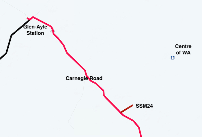
- OUTLINE OF THE GREAT WESTERN WOODLAND – the largest temperate woodlands left on earth.
![]()
-
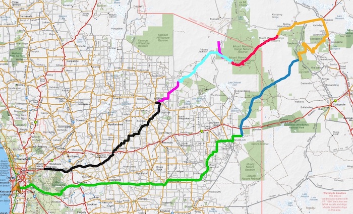
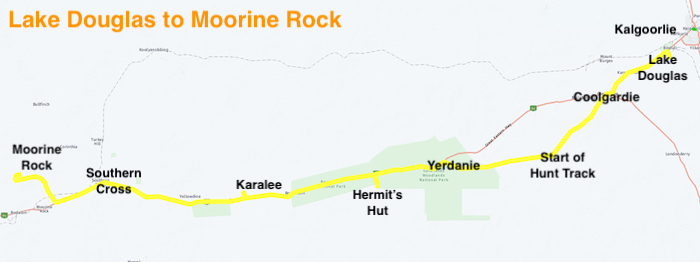
- ROUTE OF THE ROAD TRIP
Our Meeting Place was Mukinbudin. This north-east Wheatbelt town boasts a fantastic caravan park. Well appointed ensuites and one of the best camp kitchens you’ll see anywhere. Friendly, helpful and accommodating staff. The Club has stayed there a number of times when exploring the area or as a kick off point for points further afield.
-

- Rod prepared a sumptious meal in a camp oven at the community firepit.
Elachbutting Rock
The first stop of the Road Trip was Montys Pass at Elachbutting Rock, on the north-western edge of the Great Western Woodlands. The ‘tunnel’ that is Montys Pass was caused by a gigantic rock slip. Kings Cave, at the end of Montys Pass is, more correctly, a tafone.
-

- Justin, Zeljko, Charlotte and Amy entering Montys Pass.
-

- The ‘wave’ at Elachbutting Rock.
The view from the top of the rock is always worth the short drive to the summit.
Sandplain Track
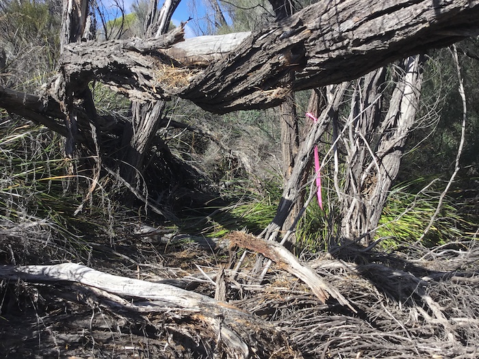
The track out of Elachbutting to the Sandplain Track disappeared into bush. When we later saw its eastern end (where we had planned to go), it was fenced off. Adverse possession or incorrect cadastral information?
-

- The inaccesible connector track to the Sandplain Track.
Not to be daunted we headed to Hobbs Road at the southern end of Elachbutting Rock. It leads directly to farmland and then follows fencelines to the Sandplain Track. This short (24km) track leads to the Mount Jackson Road. A downpour that hit as we were negotiating the Track, while extremely heavy for a short time, didn’t adversely affect our progress. We connected with the Mount Jackson Road at a granite outcrop that had been developed as a water source for a now abandoned cattle station.
Mud Holes on Mount Jackson Track
The downpour we experienced while on the Sandplain Track had, along with recent previous rains, created a number of mud holes on the Mount Jackson Road for the next several kilometres.
-

- Rod takes his Hilux through the mud.
-

- Jo and Andrew in their Prado.
-

- Zeljko took it slowly.
-

- Greg took his Disco through the slop.
-

- Greg in his BT50.
-

- Gilbert in his Prado.
Hamersley Lake
The Mount Jackson Track crosses Hamersley Lake about thirty five kilometres before the Mount Jackson Goldfields. With Lake Deborah, Lake Seabrook, Lake Baladgie and Lake Walton it is one of the many salt lakes in the area.
-
- Corduroy of logs across the lake allowed vehicles to cross with confidence.
-

- Disappearing, historic structures like this need to be protected.
Mount Jackson Homestead Ruins
On arrival at Mount Jackson Homestead ruins it looked like a 4WD Gathering. With the Toyota Land Cruiser Club, a private convoy and our group, parking was at a premium.
-

- Just some of 4WDs at the ruins.
-

- The ruins of the Mount Jackson Homestead.
-

- Mount Jackson ruins.
-

- Mount Jackson ruins.
Leaving the homestead, we made a brief visit to the cemetery and then followed the Helena and Aurora Range track eastward.
Mining Activity
A road realignment at the Marda Mine caused minor angst. The track to the south-west of the mine had been realigned to pass around the north-east and then join with the Bullfinch Evanston Road. After a drive of 800 metres on this road we were able to resume our track towards Bungalbin, the highest point in the Helena and Aurora Range.
At Marla Dam the track deviates around the Boondinie Mine.
-

- The remnant posts in the water were used to support a roof that lessened evaporation.
There is evidence of gold mining activity everywhere.


About halfway to Bungalbin, Rod’s Hilux went into limp mode. Long story short he departed for Southern Cross with Gary as escort and on the way the vehicle came out of limp mode. However, he decided it was wise to continue on the journey towards home. Gary retraced his route and rejoined us at our campsite just inside the Mount Manning Reserve.
-

- The view from Zeljko’s camp.
-

- Sunset.
It had been a very full day.
Jimbine Rockhole
The next day we drove to a rarely-visited, aboriginal water source known as Jimbine Rockhole.
C.E. Dempster, Andrew Dempster, Charles Harper, and B.D. Clarkson explored this area in 1861. Charles Cooke Hunt travelled through the area in early 1864 and Clarkson, Harper and Lionel Lukin were there again in mid-1864, when they located Jimbine.
-

- The water point is in a small gully.
It is difficult to determine how many people have visited it since these explorers located it as a vital supply of water in their search for new pastoral land. The lack of rusted cans and other rubbish and the presence of numerous, ancient artefacts indicates very little visitation.
-

- Andrew and Justin helped Greg plug a tyre.
We found our way back to the main track and pushed on towards Bungalbin. Not unexpectedly (being easter) the campground there was well patronised.
Bungalbin
We met nine members of the Toyota Land Cruiser Club (TLCC) coming down the hill as we were going up. After brief negotiations it was decided that the larger TLCC convoy would wait for our group to ascend to the open area where we had fortuitously met before they descended. Inexplicably, after this was decided, the Trip Leader proceeded to descend against our ascending vehicles.
Eventually all our vehicles reached the viewing area carpark at the top of Bungalbin. We stopped for lunch with plenty of time to appreciate the view to the north-east.
Hunt Range Track
The Hunt Range Track starts at the Bungalbin turnoff and heads north-east for 81 kilometres to the Evanston Menzies Road.
-

- HUNT RANGE TRACK
-

- Bram and Greg at Kurrajong Rockhole.
-

- Kurrajong Rockhole
Curara Soak is a further 27 kilometres along the Track.
-
- Curara Soak
-

- The Soak is in good condition.
-

- Gedagie Soak needs some work.
At Maninga Well there is an alternative track east to Ularring Soak, located just to the east of the Davyhurst Road.
-

- Maninga Well is under a tree and difficult to spot from the Track.
We camped a few kilometres past Maninga Waterhole in a suitable open area a few metres off to the side of the track.
-

- Sunset at Maninga.
Resupply at Menzies
Next morning we went past Mulline mine on the way into Menzies to refuel.
-

- Gilbert and Bram reinflating tyres before heading into Menzies.
Greg was having issues with his fridge and a fuel leak so he decided to leave the Road Trip here. Two vehicles down. The remainder continued south on the bitumen to Goongarrie to pick up the north-east end of the Gus Luck Track – although there is some suggestion that the Track may have continued to Menzies.
-

- Deflating tyres on the track into Goongarrie.
Gus Luck Track
In the 1890s renowned bushman Gus Luck pushed through a track from Southern Cross to the 90 Mile, as Goongarrie was known at the time, to supply prospectors and miners at this early gold find. Today’s re-constructed track, with a few small re-alignments, is known as the Gus Luck Track. Between Goongarrie and Coonmine Well only some sections of the Track can be driven, however, there are alternative routes to connect these driveable sections.
-

- GUS LUCK TRACK
At its start the Track has totally disappeared between Southern Cross and Duladgin and, in any case, following it would be extremely problematic owing to the existence of a sturdy, north-south vermin proof fence that completely excludes access to the area.
For convenience, the Track today starts at Yellowdine and heads north to Weowanie, the first location on Luck’s original track. Weowanie is also part of the earlier Hunt Track, pushed through in 1865-66.
To Lower Goongarrie
The upper part of the track – between Goongarrie and the boundary of the station at Lower Goongarrie – crosses many creeks and is difficult to follow at these locations. Several times I had to search around on foot to pick up the track, however, there were no problems in crossing them.


The track from Goongarrie brought us out to a service track for a pipeline and powerline connecting two mines. We had to head south and then take the Davyhurst Road north to Wangine to get back to the Gus Luck Track.

Wangine
After lunch at Wangine we explored the breakaway, a fine example of one of the most notable features of inland Western Australia.

Wangine was an important staging post on the Gus Luck Track. The Wangine Hotel that had catered for travellers and teams on the Southern Cross to Goongarrie Track (Gus Luck Track) was shifted 15 kilometres south-east to the now-abandoned gold mining town of Siberia in 1902.


The original Gus Luck Track is difficult to follow between Wangine and Coonmine. In some places where the the track is known it is overgrown and not able to be driven. In other places the route can only be extrapolated and other tracks must be used to get to the various original sections that can be driven.
-
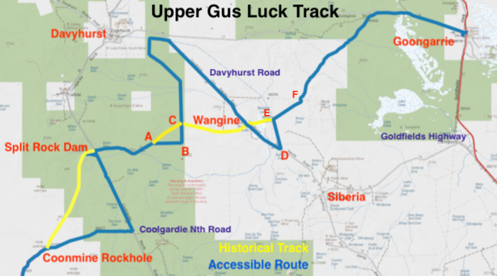
- UPPER GUS LUCK TRACK – the Blue Line shows that part of the Track that can be driven. The Yellow Line is the historical track that cannot be driven.
After travelling from Wangine to Point C on the map above, via Davyhurst Road, we stopped to search for any sign of the historical track east to Wangine. A Lands & Surveys bench mark (see photo below) was located at the point where the historical track crosses the more recent north-south track that we were on.
-

- An overgrown, barely discernible section of the historic GLT extends from this benchmark to Wangine and also south west towards Split Rock.
Locating the Historic Track
A short walk east along the supposed historic track turned up some artefacts (rusted cans and horse shoes), confirming that it was indeed the original Gus Luck Track.

We continued on Gus Luck Track to Coolgardie North Road. From this point (actually Split Rock Dam a kilometre further on) the historical track is not accessible so we continued south along Coolgardie North Road, turned west on the Coonmine Well track and found a campsite among the Goldfields Blackbutts.
Zeljko decided to continue homewards rather than camp the night. Three down.
Continue on the Gus Luck Track
Gilbert and Bram had to head home today as did Justin, Amy and Charlotte. They returned to the Coolgardie North Road, turned right towards Coolgardie and the remaining convoy continued along the Gus Luck Track.
First stop was Coonmine Rockhole, also known as Frost Soak.
-

- Coonmine Rockhole aslso known as Frost Soak.
Turturdine
-

- Turturdine Rock.
-

- Plaque commemorating Gus Luck at Turturdine Rock, installed by some of his descendants.
-

- Turturdine Well.
Next stop was Urdardanging Rock where there is a covered soak with plenty of water and a grave, most likely for a dog, 100 metres distant. This rock and Turturdine were often confused in official records. Urdardanging was also known as Dookie Rock.
-

- Tassy and Jo.
-

- Greg and Andrew.
For many years the GLT east of the Mount Walton haul road diverted away from the original Track. Some agency (most likely DPaW) has improved a nine kilometre section of the track, bypassing a long washaway and realigning it with the historic route. Perhaps the engineer responsible for planning the route or the plant operator creating the change was aware of the historical inaccuracy as reported on this website here and here.
71 Mile Rock and Well
The short track into this rock is narrow and overgrown.


The track improvements continued for some kilometres south-west of 71 Mile Rock. Though the GLT was never a 4WD ‘challenge’ this work has made it even less so.
Wallangie/Ives Rock
For many years Wallangie was known as Deadmans Soak, because of a nearby grave of an unknown pioneer. Government Dogger Roly Dimer, who had worked in the region from 1957, supplied the name.
Until 2005 Ives Rock was known as Ive Rock. Investigative work by Ian Elliot, noted bush historian, author of a number of books, developer of Hanns Track and long time contributor to Western 4WDriver caused the name to be corrected to Ives, the surname of the two men who buried the unknown man in the grave 200 metres to the west of the Rock.
-

- Jo and Andrew at the grave of an unknown pioneer.
Wallangie was a large and important water point on Juardi Station.
-

- Wallangie Soak
-

- Wallangie Dam
We had lunch, walked up the rock, found some 130 year old graffiti and then continued our drive.
-

- J. Roberts thought it necessary to peck out his name in 1895. Graffiti or historical work?
-

- View from Ives Rock.
Ullambay Well
-

- Ullambay Well
-

- Ullambay Well
Blazed Desert Kurrajong Tree
This tree is reasonably easy to spot about six kilometres before/after the railway depending on direction of travel. Desert Kurrajongs have leaves that are generally brighter green than surrounding vegetation, making them stand out.
-

- It is difficult to decipher what has been blazed into the tree and it is not known who blazed the tree.
Darrine
Two and half kilometres after crossing the Trans Australian Railway we arrived at Darrine Waterhole.
-

- Gary ans Andrew at Darrine.
The cover of the rockhole at Darrine has names scribbled all over it, dating back many years.
-

- Signatures and other scribblings on the lid at Darrine Waterhole date back to the 1930s. to
Eva Lake
Fortunately, this potential ‘track blocker/trip stopper’ presented no issues. There was only a few millimetres of waters in the lake at the point where the Track crosses it.
Weowanie Rock
We arrived at Weowanie, walked to the summit and had a look at a number of water catchments.
-

- A fine example of the effect of holoclasty.
-

- Cairn at the top of Weowanie
-

- Hunt’s Tank at Weowanie.
The track after Weowanie can be very sandy and, because it crosses the southern extension of Lake Deborah, it can sometimes be impassable.
-

- Southern extension of Lake Seabrook.
-

- Greg takes his Disco through the mud hole.
-

- Gary takes his Pajero through a mud hole on Weowanie Track.
-

- Andrew and Jo in their Prado through the mudhole.
-

- It was a little bit boggy but no real issue.
Duladgin
The track from here back towards Weowanie is the start of the authentic, driveable Gus Luck Track.
At Duladgin is the grave of a pioneer who died in tragic circumstances – often repeated in those desperate days of privations, loneliness and sometimes despair. Locating Thomas Davidson’s grave here after he blew his brains out with a firearm in 1895 ensured a visitation that it would otherwise never get.
-

- Thomas Davidson’s grave.
The well at Duladgin has been noticeably deteriorating over the years.
-

- Duladgin Well 2023
Yellowdine
We arrived at the Yellowdine servo at 3.58 p.m. – just beating the 4.00 p.m. closing time. Yellowdine is effectively the end of the accessible Gus Luck Track and the start of our homeward journey.
Mount Palmer Track
It was then time to tackle Mt Palmer Track, an unmaintained 12 kilometre dirt track that extends from Great Eastern Highway to the Marvel Loch Road. When wet the depth of the water in the mud holes can exceed 800mm. It is not a track to be taken lightly.
-

- Believe the signs.
-

- Along Mount Palmer Track.
After a brief stop to take the obligatory photo of the still standing arch of the entry to the now demolished Mount Palmer Hotel, we found a campsite nearby, replete with relics from a time past (actually just rusted tin cans).
-

- Not much left of the Mount Palmer Hotel.
-

- Very informative board at the site of the Mount Palmer hotel.
Frog Rock
The reason for visiting Frog Rock is that I had never been there before.
-
- Frog Rock
There is no reason recorded in the official database for the naming of the rock and as it is not in the shape of a frog it would be a reasonable assumption that frogs were common when it was first visited.
-

- Frog Rock Well
-

- Frog Rock Well
It is a pleasant diversion on the drive through the district without being spectacular – or indeed having any particular feature that would draw one back there.
Mt Hampton
This is an impressive water catchment project. Water is harvested from the bald granite outcrop in a similar manner to that employed on dozens of other granite outcrops in the Yilgarn Craton, stretching from the south-west corner of Australia at Augusta to the desert north-east of Kalgoorlie.
-

- Parking area at Mount Hampton.
The reservoir created by the earthen storage dam built on the eastern side of the rock would have to be the largest such water storage facility at a granite outcrop in WA.
-

- This view shows about half of the reservoir. The water is used by locals on an ‘honour system’ of recording how much they take and then pay for at a later time.
Holleton Track
The way into the now abandoned gold mining town of Holleton has been overcome by the development of larger roads on a different alignment, leaving the once thriving settlement isolated and lonely.
-

- A very slippery, greasy mud hole on the track into Holleton.
It took a bit of back and forth in 1L to negotiate the last metre of the mudhole. It was only then that ‘chicken track’ was spotted.
When operational between 1925 and 1942 it was a very rich gold producing area, yielding more than 10 times what is viable for open cut mines today.
The gold has gone, as have the people. A few relics remain in a 50,000 acre patch of unreserved bushland criss crossed by shotlines, mostly likely made by more modern day seekers of mineral wealth.
-

- All that is left of the steps of the boarding house.
-

- Site of the local school.
Old Beverley Rd
The Old Beverley Road runs well beyond the current day eastern boundary of the Shire of Beverley. The reason for this is that that when the Shire was established in 1871 its eastern boundary extended 1200 kilometres to Eucla, encompassing a huge area. By 1923 the boundaries that exist today had been established.
The upshot of this more-than-a century old political rearrangement of influence is that the Old Beverley Road extends 138 kilometres from near Narembeen to Beverley. Over this distance it changes from sealed to unsealed numerous times as it aligns with many other differently named roads that re-align or alter direction after a distance. Following the road without having to do an unplanned U turn requires close attention.
The Road Trip finished at the historic town of Beverley.
© 2023 Kim Epton
Feel free to use any part of this document but please do the right thing and give attribution. It will enhance the SEO of your website/blog and that of the Cockburn 4WD Club.
3112 words.
102 photographs.
7 images
Photographs
Kim Epton
Tassy Epton
Gary Arcus
Zeljko Zagorac
See Terms of Use