
Centre of Western Australia to Lake Douglas
-

- ROUTE FROM CENTRE OF WA TO LAKE DOUGLAS
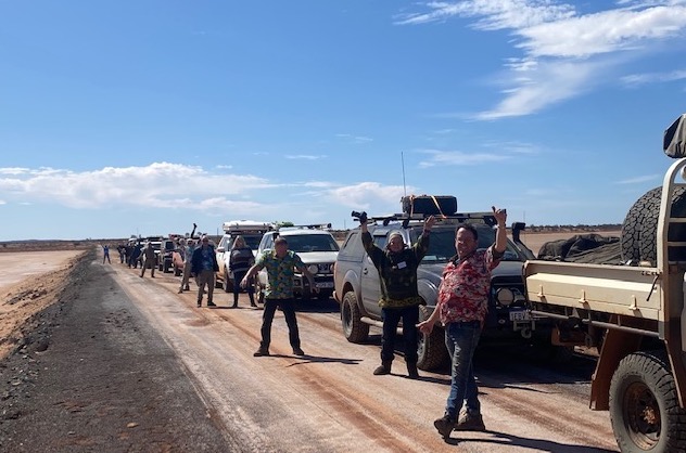
The expedition made its way out to Glen-Ayle Carnegie Road, after which time Gary took over as Trip Manager. In masterful fashion he proceeded to get the expedition back on schedule. It was important to reach Laverton this night because we had arranged for the managers of the Great Beyond Explorers’ Hall of Fame and Visitor Centre to open the venue tomorrow 30 minutes earlier than normal, specially for us.
-

- Gary took over as Trip Manager and outlined how we were going to make the push to Laverton.
Carnegie Station
Carnegie Station was the first milestone in our push to Laverton. Diesel $3.25L. There was a buzz at the station as they were preparing for muster two days hence, and a dozen or more casual hires were expected to arrive in the next 24 hours. Accommodation, catering, two beers, and $200 per day.
-

- Carnegie Station is a long way from anywhere.
-

- Welcome to Carnegie Station
-

- Disco through the front gate.
Carnegie is on the south-western edge of the Little Sandy Desert, about equidistant between Perth and Alice Springs. It is an important stop for travellers on the Gunbarrel Highway.
-

- Carnegie Homestead
-

- At the Homestead.
-

- Mike refuelling his Nissan Patrol at Carnegie. $3.25/L.
-

- Vehicles ready for the start of mustering.
After ‘information received’ discussion took place over the track to Prenti Downs – our planned route. After further investigation it was determined that the information about the track was presented (innocently) from a position of ignorance/inexperience. As it is a mapped road (rather than a station track) we elected to stay with our planned route and, as events unfolded, it was an easy drive. If we had taken the alternative route it would have been an extra 325 kilometres – it was never really an option. Just as we were about to depart Shaun noticed that the right rear tyre of his Prado was leaking air. The quickest solution was to swap the wheel.
Prenti Downs
-

- Cameras record the entry of vehicles to the Station. Biosecurity is stated as the issue, however, there are many other reasons the station managers wish to control access to the property and know who is on it.
We arrived at Prenti Downs Station just as the daylight was starting to fade. After talking with the station managers and, given the lateness of the hour, we changed our route to arrive at the Great Central Road further east than we had originally intended. Darkness fell as we travelled towards Cosmo Newberry. It was difficult to see the crepuscular wildlife and, sometimes, even the track.
-

- It was well after 5.00 p.m. when we left Prenti Downs, heading for the Great Central Road..
After turning right onto Great Central Road it was not long before we hit the bitumen, arriving at Laverton Caravan Park just after 8.00 p.m. Set up camp, shower, dinner.
A taxing drive, a long day, a successful but tiring event.
Laverton
Today is Loud Shirt Day. It is also a scheduled visit to the Great Beyond Visitor Centre. Coffee, information, education – an hour well spent.
-

- At Laverton Hall of Fame.
-

- Steve, Louise and Donna left the Road Trip here. Justin and Tayla also had to leave and make the long trip back to Perth.
It was time for Scotty to again be Trip Manager – it is his country.
We headed south out of Laverton and around the sunrise Dam Mine, boldly driving along a mine road that locals use for transit through the mine. No one stopped us so it was on with the journey south.
Lake Carey
We crossed the southern end of Lake Carey.
-

- Lake Carey, at the south-east end.
-

- Lake Carey
-
- Our convoy on the Lake Carey causeway.
This a heavily mined and prospected area. Evidence of years of mining is everywhere,
-

- Tailings dumps.
-

- Disused pit.
Bindah Breakaway
The spectacularly eroded geological feature at Bindah Breakaways is facetiously called Linden Bridge.
-

- Linden Bridge at Bindah Breakaway.
-

- Mike at Bindak Breakaway.
-

- Graham and Shaun
-

- Bindah carpark
-

- Bindah Breakaway

It was then onto Tin Dog Mine where we stopped for lunch. Scotty and son Jake gave us an extensive tour of their Tin Dog Mine and showed us their small scale gold getting process.
Tin Dog Mine

-

- At Tin Dog Mine
-

- Working a trench at Tin Dog Mine.
-

- Gold bearing ore.
-

- Kitchen at Tin Dog Mine.
We left Tin Dog and drove to a disused open cut pit for more interesting commentary by Scotty imparted further commentary on the geology.
-

- Scotty at a disused open cut pit.
-

- Inside the pit.
-

- Attentive audience.
With lots left to see and do we had to leave the mine and continue the Road Trip.
Edjudina
-

- Abandoned house at Edjudina. It was re-roofed by a local mining company in recent times and used as an office.
-

- Kim and Scotty at Edjudina.
-

- Lots of these at the Edjudina Cemetery
After visiting the Edjudina Cemetery we camped on the lee side of a hill to the west. It was still windy but it would have been considerably worse on the other side of the hill.
-

- Our camp at Edjudina.
-

- Edjudina campfire.
Yarri Station and Mine
Rob and Tracey volunteered to be Trip Managers for today.
There is a lot of mining and drilling activity at and around the Yarri Station Homestead. We tried to announce our presence but no one was interested so we drove on through. And later repeated the action as we found our route to Monaghan Well.
-

- Yarri Station
-

- Another abandoned building. Used for many years by mining companies but now empty.
-

- The track south towards Monaghan Well was through the Yarri junkyard that was also doing duty as a storage area for drill samples, old tyres and other mining equipment.
-

- Derelict truck at Yarri.
-

- Steve and Shaun at the abandoned Yarri Pub.
-

- The abandoned Yarri Pub.
-

- Wire winder at the abandoned Yarri Pub.
-

- Sue at the abandoned Yarri Pub.
Monaghan Well
Tracey called a stop at Monaghan Well after tackling a slow, overgrown track for many kilometres. It was her first time driving such an arduous track and, while a great experience for her, it will pale into insignificance after she drives more of our Road Trips.
-

- Abandoned dwellings such as this are an all too frequent sight in the bush.
-

- This dray is in remarkably good condition considering its age.
The track opened out and after negotiating several road realignments resulting from the construction of the Tropicana Highway we were able to find our way to Kirgella Rockhole for lunch.
Kirgella Rockhole
-

- Helmi, Jeff and Mike.
-

- Sue, Jeff and Mike.
-

- Good water in the Kirgella Rockhole.
Old Pinjin
Old Pinjin has been in a ruined state for forty or more years.
-

- Old Pinjin ruins.
-

- Remains of swimming pool. Such a feature would have been an absolute luxury in such an arid area.
-

- Maria at Old Pinjin.
-

- A ship’s container repurposed as a water tank. Ubiquitous throughout the bush.
The water tank among the ruins is actually a repurposed ship’s container. These are seen throughout the bush.
Time was ticking away and we needed to head towards Kalgoorlie quicker and more directly.
Kanowna
Scotty gave us tour of Kanowna. There’s not much left today but it was a roaring town in its heyday.
-

- Tracey at a grave.
-

- Maria at a grave
-

- Site of the Kanowna Post Office
-

- Our group at Kanowna.
Lake Douglas
There was little left of the day as the convoy made its way to Kalgoorlie to refuel, resupply and have showers. People made their way individually to the overnight stop at Lake Douglas, a huge free camp area few kilometres west of Kalgoorlie. Wood was difficult to find but we managed to have a decent fire.
Nobody was interested in driving kilometre after kilometre through mud and the possibility of encountering this on the Holland Track was looking likely so it was not a difficult choice to change the itinerary. Swap Hunt Track for the Holland Track – meaning that trip would finish one day early.
Next Hunt Track and More
Back to To the Centre of Western Australia
© 2022 Kim Epton
Feel free to use any part of this document but please do the right thing and give attribution. It will enhance the SEO of your website/blog and that of the Cockburn 4WD Club.
1409 words.
57 photographs, one image.
Photographs
Micaela Anderson
Kim Epton
James Hay
Louise Leipold
Maria Wilson
Tayla Skewes
See Terms of Use